


Gaia GPS: Offline Trail Maps
3.43.96K Reviews
App Specs
- Version
- 2026.7.1
- Updated On
- License
- Free
- Downloads
- 1,000,000+
- Developer
- Outside, Inc.
- Categories
- Maps & Navigation
- Platform
- Android
Screenshots

 Analysis by AppCompare
I think Gaia GPS makes the most sense when a trip takes you beyond dependable phone coverage. It is a maps and navigation app from Outside, Inc., built around planning and following routes outdoors rather than giving turn-by-turn directions for everyday city travel. I like that focus, though it also means the app is most useful when I take time to prepare before heading out.
What the free price does—and doesn’t—tell you
The app is free to install, and its in-app purchases range from $3.99 to $199.99 per item. That is a wide span, so I would not assume every useful map or capability is included at no cost. I’d start with the free access, check what is available for the specific outing I have in mind, and only consider paying if the paid option solves a real need. The price range is not a single subscription price, and the right value depends on what you plan to use.
That distinction matters for occasional hikers. If I only need a map for a familiar local walk, a free mapping option may be enough. If I expect to rely on downloaded maps on a trip with no signal, I’d first make sure the maps I want are available for offline use in the version I’m using, then decide whether an in-app purchase is worthwhile. I would avoid buying anything simply because a longer trip sounds ambitious; the practical test is whether it supports a route I will actually take.
Planning and navigating beyond the pavement
First things first, setting up Gaia GPS is a breeze. You download it from the Play Store or App Store, and within minutes, you’re ready to explore. The interface is clean and intuitive, which is perfect for those of us who aren’t exactly tech wizards. I was pleasantly surprised by how quickly I could access various maps and start planning my route.
Choosing maps for the outing
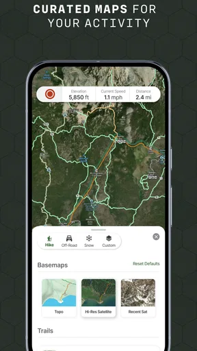
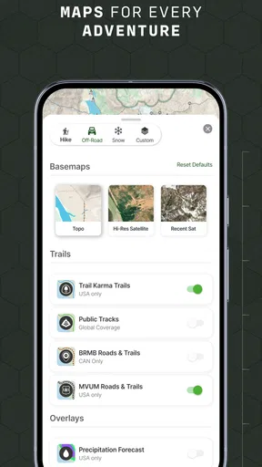
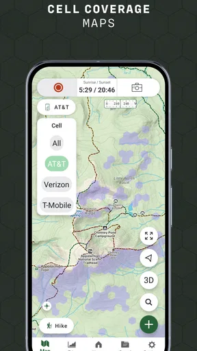
Now, let’s talk maps. The app offers a wide variety of maps, from topographic to satellite imagery, which is essential depending on your adventure needs. While planning a hike, I found the topographic maps incredibly detailed. They showed everything from elevation changes to forest cover, making it easy to plan a safe and scenic route.
Different map views are useful for different questions. A topographic view helps me think about slopes and terrain before committing to a route; satellite imagery can make the surrounding landscape easier to picture. I wouldn’t treat either view as a guarantee that a path is open, passable, or clearly marked, though. The map is a planning aid, not a substitute for checking local conditions and using judgment on the ground.
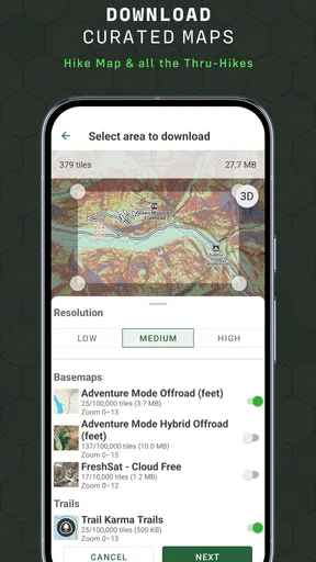
And the best part? You can download these maps for offline use. So, even when you’re deep in the wilderness with no signal, Gaia GPS has got your back. I can personally vouch for this feature, having used it in a remote area with no cell service. It was a lifesaver!
Worth Reading Before You Choose

EA SPORTS FC Mobile 26 Is a Bigger Football Game, but It Takes Time

Flipboard Shows What News Apps Must Do Beyond the Feed

Switching to Android Auto Means Rethinking Your Driving Routine

Google Calendar Makes a Crowded Week Easier to Manage

Ludo King Makes the Most of the Minutes Between Plans

Baby Panda World Brings Quick Play to Modern Phones, but Its Game Library Feels Busy
My practical habit would be to download the map while I still have a reliable connection, then open it before leaving and check that the area I need is covered. That small check can prevent a frustrating surprise at a trailhead. Offline maps help with access to the map when service drops; they don’t remove the need to carry a charged phone or to bring a backup navigation plan for a serious trip.
Following a route and keeping useful notes
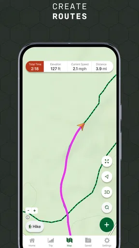
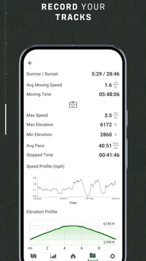
One of the standout features for me was the real-time tracking. As someone who loves to look back on my adventures, the app’s ability to track my path was fantastic. It records your route, distance, speed, and even elevation changes. Plus, you can save these tracks for future reference or share them with friends who might be interested in the same trails.
During my hike, I could see my progress on the map, which was reassuring, especially when the trail wasn’t clearly marked. The app also gives you the option to add waypoints and notes, which I used to mark interesting spots and potential campsites.
Waypoints are more useful when I give them a clear purpose rather than dropping markers at random. I might note a junction where two paths look similar, a place to stop for a break, or a spot where I want to check the map again on the return. Notes can preserve context that a track alone does not show. On a shared trip, I’d also agree with my companions what a marker means, so nobody mistakes a tentative campsite idea for a confirmed place to stay.
For a realistic day out, I’d plan a loop at home, save the relevant map for offline use, and mark the turn where the loop meets a less obvious track. Once walking, I could follow my position without relying on mobile data, then save the completed track to remember where I went. If the route looks wrong or conditions have changed, I’d be ready to turn around rather than treat the recorded line as an instruction to keep going.
Finding routes, and sharing them responsibly
Gaia GPS also boasts a strong community aspect. The app allows you to access trails and routes shared by other users, which is a fantastic way to discover new adventures. I stumbled upon a hidden waterfall thanks to a fellow hiker’s shared map, and it was absolutely breathtaking.
Shared routes are a starting point, not a promise that the outing will match someone else’s experience. Before setting off, I’d compare the route with the map, check whether the distance and terrain suit the people coming along, and think through an exit or turnaround plan. A route that worked for another hiker may depend on weather, access, fitness, or familiarity with the area. That extra check is especially important if the destination sounds remote or the path is poorly marked.
Sharing your own routes is just as easy. After my trek, I uploaded my trail with some photos and notes, hoping to inspire others. It felt great to contribute to the community and see others engaging with my content.
I’d be thoughtful about what I share publicly. A track can reveal more than the appealing destination: it can show an approach, a quiet spot, or where a trip began. If privacy matters, I’d review the route and notes before posting rather than uploading automatically. That’s a small trade-off of community features: they can help people find ideas, but the person sharing still needs to choose what details are appropriate to expose.
Personal settings and trip preparation
The app allows for significant customization, letting you tailor it to your specific needs. Whether it’s changing the map layers, adjusting the units of measurement, or setting notifications for weather changes, Gaia GPS gives you control. I found this particularly useful for setting alerts on my phone about sudden weather changes, which can be crucial for safety during longer hikes.
For me, customization is most helpful when I set it up before the trip. Choosing a familiar measurement system and map view at home makes it easier to interpret what I’m seeing outdoors, when I may be tired or in a hurry. I’d keep the screen uncluttered enough to read the route, and avoid changing settings while navigating a tricky stretch. The point is not to tweak every option; it is to make the information I rely on easy to understand.
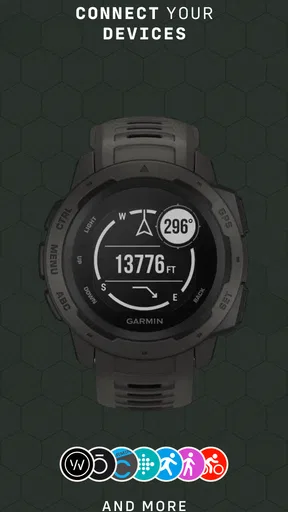
Moreover, you can sync the app with other devices, so all your data is accessible whether you’re on your phone or tablet. It’s super convenient if, like me, you prefer planning your trips on a larger screen but want the portability of a phone while hiking.
That phone-and-tablet workflow suits people who like to inspect a route at home and then carry a smaller device on the trail. I’d still check that the route and maps I need are available on the device I’m taking before I leave. For someone who plans only on a phone, the extra device flexibility may not matter; it is a convenience, not a reason by itself to choose the app.
How it compares with everyday navigation apps
Compared with the familiar map apps many people use for driving and errands, Gaia GPS is better suited to outdoor route planning, terrain-aware map reading, and trips where offline access matters. A general navigation app is often more convenient for finding a business or getting across town, and I would keep using one for that job. Gaia GPS is the more relevant choice when the route itself, the surrounding terrain, or a stretch without service is central to the outing.
It is also not a replacement for experience or basic outdoor preparation. A position marker can help me understand where I am, but it cannot decide whether a slope is safe, whether a trail is appropriate for a child, or whether it is sensible to continue in changing conditions. I see the app as one tool in a navigation setup, not the whole setup—particularly for remote or demanding trips.
Who is likely to get the most from it?
I’d recommend trying it if you hike beyond well-marked urban parks, explore backcountry routes, or want to keep a record of where you have been. It may also suit people planning off-road outings who want to inspect routes on a map before driving. Gaia GPS has a 3.4 average from around 21,000 ratings, with more than 1 million installs; that suggests it has a substantial audience, but the rating also reminds me that the experience is not ideal for everyone.
For a casual walker who sticks to familiar paths and wants the simplest possible directions, this may be more app than necessary. Someone who mainly needs traffic-aware driving guidance or a quick place search will probably be happier with a conventional navigation app. If I’m choosing Gaia GPS, it’s because I specifically want outdoor maps, route planning, tracking, or offline preparation—not because I expect it to replace every map tool on my phone.
The app is rated for Everyone, is free to install, and its current version is 2025.9. It has been available since May 17, 2010, and works on operating systems from version 11 onward. Those details make it straightforward to check basic compatibility, but I’d still look at the purchase options inside the app before planning around a paid map or feature.
Final Thoughts
In a world where technology often feels overwhelming, Gaia GPS strikes a perfect balance by enhancing outdoor experiences without being intrusive. It’s like having a knowledgeable hiking buddy in your pocket, always ready to help but never in the way. Whether you’re a casual hiker or a seasoned backpacker, this app offers something for everyone.
If you’re looking to explore the great outdoors with confidence, give Gaia GPS a try. It’s an investment in your adventures, and trust me, it’s worth every penny. So, lace up your hiking boots, download the app, and hit the trails. Who knows what amazing places you’ll discover next?
Pros
- Extensive map library for global trails.
- Offline access ensures connectivity anywhere.
- User-friendly interface for easy navigation.
- Customizable routes enhance planning flexibility.
- Integration with other devices for seamless use.
Cons
- Requires subscription for full features.
- Initial setup can be time-consuming.
- Battery drain during prolonged use.
- Limited social sharing options.
- Occasional GPS inaccuracies in remote areas.
FAQs for Gaia GPS: Offline Trail Maps
What features does Gaia GPS offer for outdoor navigation?
Gaia GPS provides a comprehensive suite of features for outdoor enthusiasts, including detailed offline trail maps, route planning, GPS tracking, and trip recording. Users can download maps ahead of time to access them without internet connectivity, making it an ideal tool for hiking, biking, and off-road adventures.
Is Gaia GPS available for both Android and iOS devices?
Yes, Gaia GPS is available on both Android and iOS platforms. Users can download the app from the Google Play Store or the Apple App Store. It offers cross-platform synchronization, allowing you to access your maps and tracks on any device you use.
How does Gaia GPS perform offline, especially in remote areas?
Gaia GPS excels in offline performance. Users can download high-resolution maps and use GPS tracking without a cellular connection. This feature is particularly useful in remote areas where internet access is unavailable, ensuring you stay on track during your outdoor adventures.
Are there subscription options for Gaia GPS, and what do they include?
Gaia GPS offers both free and premium subscription options. The premium version includes advanced features such as access to specialized map layers, high-resolution offline maps, weather overlays, and more extensive route planning tools. Subscriptions can enhance your navigation experience significantly.
What are some of the pros and cons of using Gaia GPS?
Pros of Gaia GPS include its extensive map library, offline capabilities, and user-friendly interface. However, some users may find the premium subscription cost a drawback. Additionally, while the app is feature-rich, it may have a learning curve for those new to GPS navigation.


